The Municipal Comprehensive Review Process
If you care about where your family lives, the kind of services and opportunities you have access to, the health and well-being of people in your community, or meeting global climate targets and protecting our life-sustaining ecosystems, you should definitely care about the MCR.
Learn more and get engaged with the MCR process.
Our Recommendations
Read our analysis and recommendations of the County's Land Needs Assessment for the MCR.
Learn Why The MCR Is So Important
Read our outline of the process and how it influences our environment below.
Visit The County's MCR Page
Find more information on the County's site.
Overview: Facts of the MCR
If you care about where your family lives, the kind of services and opportunities you have access to, the health and wellbeing of people in your community, or meeting global climate targets and protecting our life-sustaining ecosystems, you should definitely care about the Simcoe County’s Municipal Comprehensive Review (MCR) process.
So, what is it?
The MCR is a process that lower tier (such as municipalities in Simcoe County), single tier (municipalities such as Barrie and Orillia that aren’t part of Simcoe County) and upper tier (Simcoe County, York Region, etc.) are undergoing to decide the direction of planning until 2051. This will determine how and where forecast population growth will be accommodated, including whether or not more land will be required to do so.
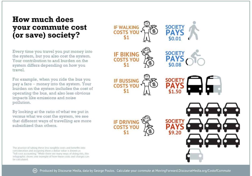
City planning, including how sprawled out or densely we build neighbourhoods, is often left out of conversations around climate action. But planning actually determines a lot about our levels of GHG emissions and pollution, energy and water use, and food production.
While provincial and federal policies are important, local planning policies have a larger impact than some of us might think – about half of domestic carbon emissions come from things that are under municipal control, namely transportation and buildings.1Act Locally: The Municipal Role in Fighting Climate Change(pdf)
Studies tell us again and again that sprawling suburbs have the highest emissions of any type of neighourhood, while dense low-rise neighbourhoods have about a third of the emissions of sprawl (which is less than tall buildings too).
The plan that comes out of this review will determine a lot about how Simcoe County residents live our lives and whether or not we meet our 2030 and 2050 climate targets.
A MCR strongly influenced by developers would like lead to more sprawl, locking in decades of unsustainable development and making it difficult and expensive to achieve climate targets.
The MCR will impact every part of our lives for years to come, whether you’re a parent, a young person, a senior, a business owner, environmentalist, or anyone else living in the County.
Map showing requests by developers for settlement area boundary expansions.
It’s important to note that these are requests only, and that, so far, the County seems to believe that far less land is needed to accommodate the population forecast for Simcoe County.
That said, there is uncertainty regarding how MZOs will figure in meeting population allocations. As it stands the MZOs approved for Simcoe County address most, and likely all, of this need.
![]() Settlement Area Boundary Expansion Requests
Settlement Area Boundary Expansion Requests
![]() MZOs
MZOs
![]() Greenbelt
Greenbelt
![]() County Greenlands
County Greenlands
![]() MNR Evaluated Wetlands
MNR Evaluated Wetlands
![]() Built Up Area
Built Up Area
The Breakdown: Steps of the MCR
Simcoe County began this process in January 2021 (despite other Counties beginning back in 2019) and it will finish in July of 2022.
The Concerns: Implications of the MCR
Provincial influences
"Compact built form and intensification efforts go together with more effective transit and active transportation networks and are fundamental to where and how we grow. They are necessary to ensure the viability of transit; connect people to homes, jobs and other aspects of daily living for people of all ages; and meet climate change mitigation and adaptation objectives. Moreover, an increased modal share for active transportation and transit, including convenient, multimodal options for intra- and inter-municipal travel, supports reduced air pollution and improved public health outcomes." (p. 12)
This has been the provincial policy framework for years, indicating some real progress.
Recently however, the Ford government has made some changes to the mandates and processes outlined in the Growth Plan. As expected, these changes favour private developers and scrap environmental protections.
One of these changes was changing the minimum population allocation targets to maximum population allocation targets, forcing much more development into low-density areas in the County instead of existing built-up areas – more urban sprawl.
Another revision required the loosening of restrictions regarding settlement boundaries. Rather than planning until 2041, this timeline has been extended until 2051. This revision “requires that municipalities open up land on their outskirts to accommodate more than 30 years of sprawl all at once rather than gradually, or not at all”. This round of MCRs, which will amend municipal Official Plans (including Simcoe County’s, Barrie’s and Orillia’s), have been changed to favour developers, which will lock in the next 30 years of sprawl, instead of slowly and smartly growing as actually needed.
“…the way planning works is tilted in favour of developers – at financial, social and environmental cost of municipal governments, homeowners and taxpayers (in other words, all of us).”
The Connections Between Urban Sprawl & Climate Change
These changes by the provincial government have exacerbated the existing issue around the influence that private developers have over our communities. Even before these changes, the way planning works is tilted in favour of developers – at financial, social and environmental cost of municipal governments, homeowners and taxpayers (in other words, all of us).
Urban sprawl creates a cycle of low density areas not having enough viable alternatives to cars, so more residents drive cars, which require more roads (and costly road maintenance) as well as pipes and other infrastructure stretched out to support the spread out single detached homes. More cars and the building of homes and infrastructure in of itself increases our GHG emissions (and habitat loss, pollution, etc) at a time when we must be rapidly decreasing emissions.
Developers must pay fees for homes they build to help with the municipality’s cost to provide infrastructure. But these fees are calculated in ways that work out to municipalities and residents paying much more to build subdivisions, while developers get hefty subsidies for these lower-density houses; and those who live in higher-density areas end up paying more to subsidize those suburbs even though they put less strain on the municipal infrastructure.
This means that we are paying for private developers to build unsustainable, inefficient and inconvenient homes, while they profit.
This traps residents into unsustainable ways of life that also negatively impact physical and mental health and stretch out our commutes from work, grocery stores and other places people need to get to, leading to more social isolation, which is a hallmark of modern society. We can see how the way our built environments are designed shape our social worlds too.
While some of us tend to think of urban areas as worse for the environment, denser urban neighbourhoods actually tend to have lower carbon emissions than suburbs.
This is partially because with buildings closer together and more attached types of housing (like fourplexes, townhouses and low-rise apartments), less energy and infrastructure is needed. Less distance needs to be travelled between places, and it’s much more feasible to use active transportation, like walking, rolling and biking to get to those places. Buildings with shared walls also require less energy to heat and cool.
Densified neighbourhoods save land, energy and infrastructure costs for taxpayers and municipalities, and are more conducive to richer social lives for their residents.
Unfortunately, these kinds of neighbourhoods are usually restricted to our downtowns (and are one of the reasons we Ontarians love our downtowns!). This is because of zoning laws that actually prohibit multi-family units and mixing of residential and commercial use buildings in most of our neighbourhoods. Alongside policies that favour urban sprawl, this results in an assumption of and defaulting to subdivisions and yet more subdivisions.
We know subdivisions are not healthy for us or the planet, so what will the MCR do about this? Well, so far, not a whole lot. And it has to do with land-use planning.
“…15-minute communities are ones in which residents are able to access basic amenities, such as groceries and other local shops, within a 15 minute walk.”
The Land Needs Assessment
The provincial government gives Simcoe County estimates on how much it thinks the population will grow and how much the County should build to fit more people and jobs. It also provides percentages of how much development must happen inside of current settlement boundaries, as well as the growth outside of these boundaries. The Ontario government has changed these percentages, so now 80% of new residents must be in suburban areas outside of the GTA, in lower-density municipalities (which includes much of Simcoe County).
This forces more people into lower-density areas, giving the illusion that more low-density housing is needed to fit them. Instead, we can densify our existing urban areas in a variety of ways that would fit these people (and add to the richness and convenience of our neighbourhoods while we’re at it!).
But municipalities must use the Land Needs Assessment Methodology (recently revised by the Ford government) to decide how many households of which kind of housing type are needed to accommodate that population.
The province had two options to calculate the population growth projections:
- They can look at the changing demographics and trends (like more intergenerational homes as senior parents move in with their children, students and emerging adults living at home longer, immigrants culturally living with extended families, and the fact that Millennials are looking for smaller homes in mixed-use neighbourhoods) that indicate that people want less single-detached homes.
- Or, they could choose a ‘market-based’ option that projects forwards from past housing trends, assuming that because people have been buying single-detached homes (despite that being really the only option) people will continue to want single detached homes decades into the future, despite demographic trends and climate science telling us that isn’t what we should be doing. The Ford government chose the latter, mandating a ‘market based’ approach.
We don’t believe this method makes sense in any way except making money for developers and land speculators. Furthermore, it amounts to borderline climate denial, ignores the systemic nature of social and public health issues, does not respect Indigenous Land rights, and assumes that Millennials and GenZ will want the same things throughout their lives as Boomers did. This is out-of-touch, at best.
The new Land Needs Assessment Methodology biases this choice about new housing towards sprawl, limiting the ability of residents and their municipalities to choose options that are better for our quality of life, public health, and climate targets.
What we are calling for, and you can too by signing our petition, link to above, is working towards achieving 15-minute communities before settlement boundaries are expanded for new development.
15-minute communities are ones in which residents are able to access basic amenities, such as groceries and other local shops, within a 15 minute walk. This is a built form that many of the world’s most forward acting cities are pursuing, and there’s absolutely no reason why we cannot do so here as well. In fact, doing so will be cheaper for municipalities and taxpayers, healthier for residents, and help us take some really big steps to both mitigate and adapt to climate change. (These reasons are precisely why this concept is gaining traction in cities around the world.)
Community supported, advocacy for a safe and secure future.
Governments have failed to act to protect our communities and the futures of our children and grandchildren, and they continue to treat our environment as if it’s incidental to life, rather than a foundation for it.
We need strong community organizations to fight for our future, now more than ever.
Please consider donating to support our work. It’s people like you who make us possible.